Trip Description
"A journey of a lifetime that all human being should have made once"
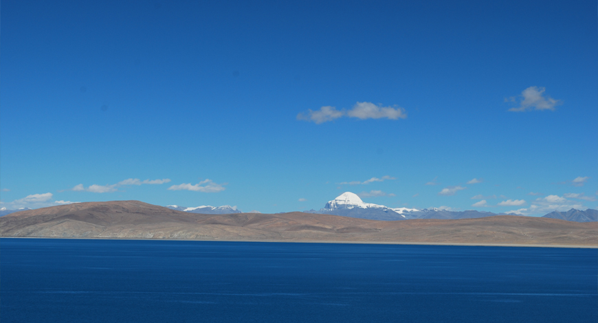
The Holy Mt. Kailash is situated at a height of 6714 m. (22156 ft.) above sea level. For four Major religions of the world, i.e. for Buddhism, Jainism, Bompo (a religion prior to Buddhism in Tibet) and Hinduism, Mount Kailash is the spot of utmost reverence. For the Buddhists, Kailash is the center point of the universe. For the Jains, Kailash is the Mount Ashtapada, a very holy place of pilgrimage. For the Bompo followers, Kailash is the nine-faced swastika mountain and is constantly emanating great power. For the Hindus Kailash is the Sumeru Parvat, the spiritual center of the world around which all the earthly powers revolve. If there are heaven abodes on earth, Mt. Kailash & Mansarovar Lake is to be treasured as the most celestial. Its flames give birth to four great Asian rivers the Indus, Bramaputra, Ganges and Sutlej.
"As the dews are drying up the morning sun light, so are the sins of human beings cleanses up by the sight of the Himalayas, where lord Shiva lived and where the Ganga falls from the foot of Vishnu like the slender thread of a lotus flower. There are no mountain like the Himalayas, for in them are Holy Mt. Kailash and lake Manasarovar." We take you to the most fascinating Kora (Circumambulation) of Kailash on foot, crossing the high pass Dolma La 5636 m. (18600 ft.) above sea level. So as you trek around Mt. Kailash you enjoy the grand views on both sides of the valley and Mt. Kailash from all directions. We also take you for the parikrama (circumambulation) of Manasarovar Lake by jeep and visit some of the Gompas and holy site on the shore of the lake.
It is indeed a rare opportunity and privilege for all devotees who have been dreaming to be close to the home of the Gods in this world.
Trip Itinerary
Trip Itinerary
Day 01: Arrival in Katmandu:
Group will be welcomed at the airport by the company representative and transferred to hotel.
Day 02: Kathmandu:
This day will be disposable for the group whereas official will process the visa formalities in order to get ready for departure for next day.
Day 03: Kathmandu-Nepalgunj:
An approximate flight duration of one hour group will be landed at Nepalganj airport. After group will be transferred at hotel for overnight stay.
Day 04: Nepalgunj-Simikot/Majgaun:
Landing at Simikot airport after 50 minutes flight from Nepalganj trek starts hiking towards at an elevation of 3800m after crossing this pass trail descends gradually until reaching at Majgaon also locally known as Tuling 2,700m. The walking span will be approximately 4/5 hours that will allow the chances of few greeneries of wheat and barley fields which is the major crops of this region. It depends upon the physical condition of the guests if they realize for any rest during these days the itinerary is flexible.
Day 05: Majgaon/Kermi 2,690m:
6/7hrs trek. The trail follows through Dharapani after breakfast and this day would be little tough. Elsewhere that would be decided by the cook lunch will be served as sometimes it would not be at the fixed place due to unavailability of water on the route. As indicated above after 6/7hrs walking we will reach at the second night camping Kermi.
Day 06: Kermi/Yalbang Chaur 2,760m:
6/7 hrs trek. Climbing over a ridge we will walk through a valley having potato and wheat fields, besides this pine forest, many cairns would be other attractions at an approximate height of 2,990m. would be really wonderful experiences of the day. Then route allows trekkers alleviation by going down to the bank of the Chumsa Khola. After crossing this river no choice we should start climbing up with a very steep and rocky escarpment and this day we can say a day several of ups and downs. Ultimately we will descend to the bank of Karnali River, and after short walk we will reach at Yalbang Chaur.
Day 07: Yalbang Chaur/Tumkot Khola 2,800m: 6/7 hrs trek. This day we shall be going little bit higher altitude of 2,890m.some villages on the route after passing a main village named Yangar; we go down walking until the trail meets a small unknown river various upwards and downwards should be met with until reaching another camping spot Tumkot Khola.
Day 08: Tumkot Khola/Yari 3,450 m 5/6 hrs trek. Another river called Bumachiya Khola comes along the route then another steep that is situated at the height of 3,310m, some mustard fields could be seen after walking through some forests we will reach at a great Jhyakthang Chu Valley stretching out before Yari. This day ends at Yari where camp will be set at the surrounding of Yari an ultimate Police Station is located here for the security of the trekkers.
Day 09: Yari/Hilsa/Sher 3500m: 7/8 hrs trek.
This day's experience will be different day to a scenery of flat valleys on the way that leads towards Nara Lagna Pass 4580m with a gradual ascending. Then immediately route descends to Ranipuwa which is we can say or consider a real trek of the day until the Humla Karnali River. The continue to walk that will last reaching Hilsa where a stone pillar signifying Nepal/Tibet border then after a short walk we will reach at Sher.
Day 10: Hilsa/Sher 3,600m /Taklakot 3,600m:
20 minutes walk from Hilsa to Sher at the moment Jeep will be awaiting there from Tibet side. on the way we will see Kocher Monstery where the prominent famous Sakya Monastery is located there was built in the 6th century. After this we will proceed our drive to Taklakot that takes around 1 and half hour to reach locally Tibetans call this place Purang a place of trading center. A expanding market is situated in the proximity of Karnali River bridge almost all shops are made of mud walls and white canvas roofs. Tibetan wool trade is another famous business of this place and another extension of the sightseeing will be at the 2,890m remains of Simbling Gompa is considered as the biggest monastery and this night will be staying at Taklakot Guest House.
Day 11: Taklakot /Lake Manasarovar 4,558m: 95km 4/5 hrs drive. Day starts by driving towards the Lake Mansarovar leaving the route of Manay Tibetan styled settlements, Gurla La pass 4,590m. we also can see other lakes including a big holy lake of Tibet. This night's camp will be set at a wonderful base of the Chiu Gompa.
Day 12: Manasarovar Lake / Darchen
Darchen 4,575m 141 km: 5/6hrs drive Guesthouse. Overnight at Guesthouse.
Day 13: Darchen/Dirapuk 4909m: 18km 7/8 hrs
After a short drive from Darchen about 4km ending at Tarpuche from where the hiking starts for an encirclement of Holy Mount Kailash. This is the first day of hiking and an opportunity of to enjoying the stupas (chortens) and sky burial site of the 84 Mahasiddas. Besides this several rivulets forcibly flowing of white water petering out beautiful cascades, a stunning view of Holy Mount Kailsha itself, in the route Chukku Monastery and ultimately day ends at Dirapuk Monastery. This is the first night camping spot.
Day 14 Dirapuk/Zutulpuk Monastery 20 km 6/7 hrs
Day will be counted as hardest one of the tour by crossing of rocky and rockeries trails that ascends to Dolma~La Pass 5,630m. Before crossing this pass there is another important holy place should not be avoided known as Gauri Kunda. After a nice break at the top of the pass we will head down the steep trail to our eventual campsite at Zutulpuk Monastery 4,790m, near the cave of miracles where Milarepa meditated.
Day 15: Zutulphuk/Darchen 15Km /Mansarovar Lake/Hor Chyu: 45 km 8/9 hrs.
Ending day of the circumambulation that will last approximately three-hour walk brings back to Darchen and the distance between Zutulphuk and Darche where the vehicles will be awaiting to transfer to the camping place in the bank of Lake Mansarovar called Hor Chyu.
Day 16: Hor Chyu/Parayang: 221 km 7/8 hrs.
Lake Manasarovar is one of the holiest lakes among others located in the land of Tibet. By following the cosmological concept of Hinduism and Buddhism on four prominent rivers named Brahmaputra, Sutlej, Ganga and Indus it is described the source that is originated with this Lake is proved to be true. You can realized the truth as these rivers starts from this Lake. You can see the astounding face of Mount. Gurula Mandhata 7,728m, Trugo Monastery and Chiu Monastery. We shall drive back to Paryang from Hor Chyu for over night stay.
Day 17: Parayang/ Saga: 241km 8/9 hrs.
Road crossing with wondrous valleys, several clean watered rivers, amazing yaks and sheep grazing pasturages, nomads, traders tour continues towards Saga. Other part of the attraction can be highlighted with marvelous landscapes, snow-capped mountain peaks, sand dunes, and typical geographical composition in the land of Tibet that make your tour worthwhile enjoying the day which lasts at Saga.
Day 18: Saga/Nyalam 241km 8/9 hrs.
After breakfast we will leave for Friendship Bridge Nepal/China border from Saga via Nyalam. After brief dealings at the Immigration at the border we proceed for lunch. After lunch we set our out journey for Kathmandu catching a tourist bus following a number of turnings of narrow road on banks of Bhotekoshi. On the route bus passes way through Dolalghat, Dhulikhel, Banepa entering into the valley of Bhaktapur and ultimately arriving in Kathmandu. Unquestionably entire tour completes with dropping guests at hotel.
Day 19: Nyalam/Kathmandu: 157km 7/8 hrs.
Options on this day has freely left at clients' disposal either choosing for mountain flight or proceed Manakamana Or Muktinath pilgrimage tours. Few capital based flying companies chartering the helicopters for this purpose in an Exclusive charge.
Day 20: Drop guests at the airport for final departure check-in further boarding on the aircraft.
Cost Includes/Excludes
Cost Includes
- Trekking guide
- Trekking permit
Cost Excludes
- Nepal Visa fee
- International Air fare
Trip Photos
Please click on small photos to have larger view!